Although many people like to travel, only a handful of us can afford to go to all the places that we would like to step foot on.
However, that does not mean we cannot travel the terrains of our favourite places on earth, virtually.
For this very purpose, Google Maps’ Street View application helps to stretch the wallet by going the extra mile especially to those who love to engage themselves with high places like mountaintops.
This is because Google Maps has enabled people to catch elaborate glimpses of four of the Seven Summits, the highest mountains on each of the seven continents of the world.
The captivating images was collected with a simple lightweight tripod and digital camera with a fisheye lens for viewers to feast their eyes.
Now you can explore some of the most famous mountains on Earth, including Aconcagua (South America), Kilimanjaro (Africa), Mount Elbrus (Europe) and Everest Base Camp (Asia) on Google Maps.
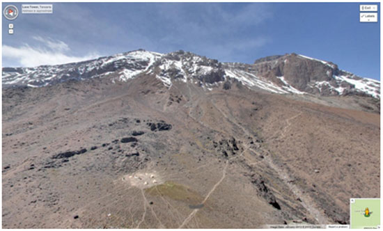
Start your adventure on Tanzania’s Mount Kilimanjaro, the dormant volcano known as the Roof of Africa. See amazing views of the highest freestanding mountain in the world covered in snow just three degrees south of the equator.
Next, travel to the tallest mountain in Europe, Russia’s Mount Elbrus, and see huts made from Soviet-era fuel barrels which climbers turn to for solace during harsh weather.
Explore Argentina’s mighty Aconcagua, the highest peak in both the Western and Southern Hemispheres. See how a base camp is set up amongst the exposed rock in Plaza Argentina and how expeditions eat, camp and prepare for their ascent.
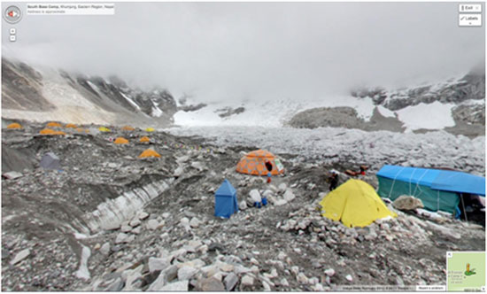
Finally, make your way to Everest Base Camp, where expeditors stage their attempts to reach the top of the world. Along the ascent, steal glimpses of the snow-capped Himalayan mountain peaks.
All these and more from the comfort of our homes or when we are on the go as the images can be downloaded in Google Maps on the iPhone and Android devices.
However, that does not mean we cannot travel the terrains of our favourite places on earth, virtually.
For this very purpose, Google Maps’ Street View application helps to stretch the wallet by going the extra mile especially to those who love to engage themselves with high places like mountaintops.
This is because Google Maps has enabled people to catch elaborate glimpses of four of the Seven Summits, the highest mountains on each of the seven continents of the world.
The captivating images was collected with a simple lightweight tripod and digital camera with a fisheye lens for viewers to feast their eyes.
Now you can explore some of the most famous mountains on Earth, including Aconcagua (South America), Kilimanjaro (Africa), Mount Elbrus (Europe) and Everest Base Camp (Asia) on Google Maps.
Start your adventure on Tanzania’s Mount Kilimanjaro, the dormant volcano known as the Roof of Africa. See amazing views of the highest freestanding mountain in the world covered in snow just three degrees south of the equator.
Next, travel to the tallest mountain in Europe, Russia’s Mount Elbrus, and see huts made from Soviet-era fuel barrels which climbers turn to for solace during harsh weather.
Explore Argentina’s mighty Aconcagua, the highest peak in both the Western and Southern Hemispheres. See how a base camp is set up amongst the exposed rock in Plaza Argentina and how expeditions eat, camp and prepare for their ascent.
Finally, make your way to Everest Base Camp, where expeditors stage their attempts to reach the top of the world. Along the ascent, steal glimpses of the snow-capped Himalayan mountain peaks.
All these and more from the comfort of our homes or when we are on the go as the images can be downloaded in Google Maps on the iPhone and Android devices.
Advertisement